The Big Dig
In 1959, Boston opened the Central Artery, an elevated six-lane highway that ran through the center of downtown Boston. In the early stage after it was built and opened to public, it carried about 75,000 vehicles a day which was under its capacity. However, in the early 1990s, as Boston’s population increased tremendously, the Central Artery highway system began to experience heavy congestion, carrying more than 200,000 vehicles a day which is about 2.7 times more than in the 60s and double of its design capacity. [1] According to the data and figures from Massachusetts Department of Transportation, traffic
jammed up for more than 10 hours each day. [1] The accident rate on the
deteriorating elevated highway was four times higher than the national average
for urban Interstates. [1]
Not only was the Interstates highway systems the victims of the increasing population growth Boston were experiencing, the two tunnels under Boston Harbor between downtown Boston, and the one connects Eastern Boston and Logan Airport also experienced heavy traffic congestions. And back then (in the 1990s), Massachusetts Department of Transportation projected that Boston would experience a stop-and-go traffic jam for up to 16 hours a day by 2010. Besides that, such traffic congestions and jams would ultimately create a salient economy cost to automobile users and downtown businesses. Moreover, the elevated highway, the Central Artery, displaced 20,000 residents when it was built, and also separated North End and Waterfront neighborhoods from downtown Boston which limited not only economic participation but also social interaction of residents from these neighborhoods with downtown Boston. The Central Artery ultimately created a blighting effect to surrounding neighborhoods. [1]
In order to resolve these problems, Bill Reynolds, the head of New England Road Builders, proposed the idea of replacing the Central Artery with a tunnel. And such idea received positive feedbacks and great interest from different levels of the city government of Boston, including the transportation department and the mayor.
However, similar to almost all urban redevelopment cases, the Big Dig (the Central Artery/Tunnel Project) involved convoluted political bargains and tangled with numerous stakeholders from both the public and private sectors. As mentioned above, Bill Reynolds, the head of New England Road Builders proposed the idea of replacing the Central Artery with a tunnel, and the idea was greatly supported by the mayor but environmental and community activists favored replacing the Central Artery while opposed the tunnel. They feared the underground construction phrase would pollute and impact the habitats in the Charles River and also the Boston Harbor. On the other hand, the business community wanted the tunnel but was worried about the economic cost, and also impacts to downtown businesses during construction. But local communities, at the same time, opposed the tunnel because they were afraid of the potential additional demolition the neighborhood would suffer. Lastly, a big transportation project like this would involve significant amount of budget,Boston citizens, especially taxpayers, worried about it too.
Fred Salvucci, then, proposed an idea that would please both sides: to replace the Central Artery with a tunnel under downtown Boston and extended I-90 east through a new harbor tunnel (Ted Williams Tunnel) directly to Logan Airport, to avoid creating social and economic impacts to surrounding neighborhoods and businesses while limiting environmental impacts to Charles River and Boston Harbor. [1]
The project’s two major components:
- Demolishing and replacing the six-lane elevated highway with an eight-to-ten-lane underground expressway directly beneath the existing road to restore open space on the ground level, and a two-bridge crossing of the Charles River. [1]
- Extending the I-90 (the Massachusetts Turnpike) from south of downtown Boston through a tunnel beneath South Boston and Boston Harbor to Logan Airport. [1]
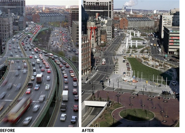
After the 24 years long project was completed, traffic congestion improvements were salient. The total vehicle- hours of travel on Project highways has dropped 62 percent between 1995 and 2003 and are now providing approximately $168 million annually in time and cost savings to travelers. [1] According to data from the Massachusetts Department of Transportation, the average travel times of south and west Boston citizens from the I-90/I-93 interchange to Logan Airport during peak periods have shown a 54 percent decrease on average. [1] Data from the Massachusetts Department of Transportation also indicates that a 12 percent reduction in citywide carbon monoxide levels was achieved. [1]
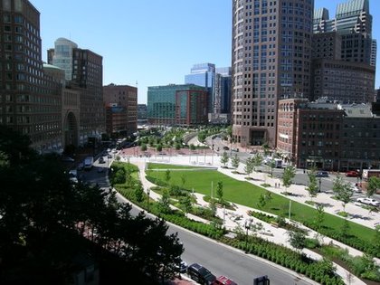
Besides reducing travel time and traffic congestions, and providing economic benefits. The Big Dig also changed numerous positive environmental and social impacts. For instance, the lands that were used to be occupied by highway lanes are now public plazas, green parks, and open spaces. According to Massachusetts Department of Transportation, the project created
more than 300 acres of new parks and open space, including 27 acres where the existing elevated highway stood. [1] And the rest of those open spaces are left for modest development, including retail, commercial, and housing uses in low-rise buildings. Moreover, the Big Dig also creates some intangible social impacts to citizens of Boston. By clearing the downtown highway lanes and building them underground, the project, indeed, makes downtown Boston a safer and more attractive space for pedestrians. By doing that, it ultimately changes many Boston citizens’ mode of traveling, shifting from driving to biking or even walking.
references:
1. The Big Dig - Highway Division. (n.d.). Welcome to MassDOT. Retrieved March 7, 2013, from http://www.massdot.state.ma.us/highway/TheBigDig
2. Transportation | People, Places & Planning in Boston. People, Places & Planning in Boston. Retrieved March 7, 2013, from http://planningboston.org/planning/transportation