The Era of Revitalization - Transportation
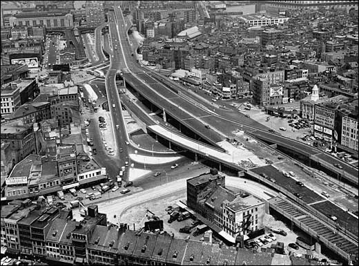
Figure 3: Central Artery Highway
After the end of World War II, the United States experienced a dramatic economic boom. Boston had slowly emerged from decades of financial and economic stagnation to promoting large investments in federal infrastructures. Among the major project developments conducted by the city was the federal highway system – the Central Artery.
The majority of the roads and highways were constructed in the early decade of this automobile era. The renowned Tobin – Mystic River – Bridge and Storrow Drive were opened in 1950 and 1951 respectively.[1] Commencing the construction for the Central Artery in the early 1950s – officially known as the John F. Fitzgerald Expressway, was a highway that would allow accessibility crossing through the heart of downtown Boston and completed for opening in 1956. This long stretch of highway slashed through the center of downtown Boston and interconnected from one nodal point to another. With the placement of Route 128 and the Southeast Expressway joined together by the late 1950s lead to the construction of the Callahan Tunnel in the 1960s, the rest of I-93, Route 3, and Mass Pike extension were all webbed together to the core Central Artery highway system.[1]
The initiation of these rapidly erected highways came with a great price tag – not only financially but socially as well. Many neighborhoods and communities had to be demolished in order to facilitate the placement of highways and roads. The Mass Pike required homes and businesses to be torn down in Newtown, Chinatown, Brighton, and the South End. Homes and businesses existing along the Mystic Parkway in Medford and Somerville were forced to be destroyed providing room for the I-93.[2] Storrow Drive trampled over parkland fore taken by the city, initially willed specifically to be a forbiddance for road construction and development.
Among all these destructions, the largest scar implanted across the city of Boston was the positioning of the Central Artery. This highway system lead to the bulldozing of numerous homes and businesses in Chinatown, Waterfront, North End, and Bulfinch Triangle – causing the loss of shelter, protection, and income for many families and children.[1] The surviving neighborhoods now must witness the blighting impact of the elevated highway. The flaw in constructing the elevated highway system – the Central Artery – through the heart of Boston was recognized even before the construction was completed. In order to facilitate the last stretch of the Central Artery, this segment was built under a tunnel running from Dewey Square through Chinatown.[1] Unfortunately, economical and political benefits surpassed the level of environmental justice and impact to continued the development of this massive highway.
The demolishment of homes and businesses were the price Boston paid in regards to urban renewal. Homes and businesses were lost and destroyed in order for the city to expand and develop into today’s modern scene of parking and auto-centric designs. All of this demolition and production led to the profound turmoil and uproar that characterized this era. City planners and policy makers intended these automobile infrastructures and modern expansions to attract and engage families to return back to the city, but instead sped up the process by pushing more households into the suburbs. These major projects only encouraged more and more individuals to abandon the main city and travel more conveniently commuting from suburban homes.
From the major developments in the federal infrastructure system, the highway revolt led to a remarkable change in the planning of transportation development in the city of Boston. Virtually a half century of organization and planning in the construction of highways aiming for the sole purpose to move automobiles around the city, the shift in perspective suddenly changed to promote and engage productivity and efficiency by establishing what was best beneficial to the residents of Boston.[1, 2] The emphasis on public transportation and mass transit, pedestrian networks and accessibilities, and roads and open spaces were among the major development goals carried out by Governors Sargent, Dukakis, and the Secretaries of Transportation Alan Altshuler and Fred Salvucci.[1] With these four visionaries of public transportation eager to promote a New Boston, redirection of funds and land originally dedicated for highways were converted to constructing and promoting the production in the commuter rail system – extension of the Red Line, relocation of the Orange Line, and construction of the Southwest Corridor Park.[1] The Dukakis administration also established a ban on parking in downtown Boston that guaranteed empty lots in downtown that would not be wasted or misused for roads or highway constructions.[2]
Leading to the fuel shortages, energy crisis, and pollution concerns during the 1970s, the pivotal point towards the reduction in automobiles and other forms of transportation. The Boston Transportation Planning Review (BTPR) from 1971 to 1972 initiated the process and plan toward this shift in energy conservation and environmental preservation.[2] Among the following orders BTPR aimed to overcome and surpass predecessor planning included the limited breadth of evaluation, scale, lack of citizen participation, and modal bias towards autos. This new plan of order intended to balance solutions with the problems occurring during the current period along with long-range benefits and initiatives to bear costs and minimize financial costs and environmental pollutions while organizing an efficient and productive transportation network.
The Boston Transportation Planning Review initiated the following criteria in the improvement of transportation:[3]
With the placement of the Central Artery highway, Boston witnessed a scar slashed through the heart of downtown. Many homes and businesses were destroyed to compensate for the infrastructures of the transportation network that extended throughout the city to provide access for automobiles. Realizing the devastated impact of the elevated highway construction to the city, goals and regulations were established to help prevent future demolition of homes and businesses.
References:
1. Abraham, J. (1948, January 1). Central Artery separates neighborhoods. Retrieved from http://www.xtimeline.com/evt/view.aspx?id=50299
2. Dukakis, M. S., & Dukakis, K. (2012, February 12). Why does it cost so much to live in Boston? . Retrieved from http://www.northeastern.edu/dukakiscenter/why-does-it-cost-so-much-to-live-in-boston/
3. Puleo, S. (2010). A city so grand: The rise of an American metropolis. Boston: Beacon Press.
The majority of the roads and highways were constructed in the early decade of this automobile era. The renowned Tobin – Mystic River – Bridge and Storrow Drive were opened in 1950 and 1951 respectively.[1] Commencing the construction for the Central Artery in the early 1950s – officially known as the John F. Fitzgerald Expressway, was a highway that would allow accessibility crossing through the heart of downtown Boston and completed for opening in 1956. This long stretch of highway slashed through the center of downtown Boston and interconnected from one nodal point to another. With the placement of Route 128 and the Southeast Expressway joined together by the late 1950s lead to the construction of the Callahan Tunnel in the 1960s, the rest of I-93, Route 3, and Mass Pike extension were all webbed together to the core Central Artery highway system.[1]
The initiation of these rapidly erected highways came with a great price tag – not only financially but socially as well. Many neighborhoods and communities had to be demolished in order to facilitate the placement of highways and roads. The Mass Pike required homes and businesses to be torn down in Newtown, Chinatown, Brighton, and the South End. Homes and businesses existing along the Mystic Parkway in Medford and Somerville were forced to be destroyed providing room for the I-93.[2] Storrow Drive trampled over parkland fore taken by the city, initially willed specifically to be a forbiddance for road construction and development.
Among all these destructions, the largest scar implanted across the city of Boston was the positioning of the Central Artery. This highway system lead to the bulldozing of numerous homes and businesses in Chinatown, Waterfront, North End, and Bulfinch Triangle – causing the loss of shelter, protection, and income for many families and children.[1] The surviving neighborhoods now must witness the blighting impact of the elevated highway. The flaw in constructing the elevated highway system – the Central Artery – through the heart of Boston was recognized even before the construction was completed. In order to facilitate the last stretch of the Central Artery, this segment was built under a tunnel running from Dewey Square through Chinatown.[1] Unfortunately, economical and political benefits surpassed the level of environmental justice and impact to continued the development of this massive highway.
The demolishment of homes and businesses were the price Boston paid in regards to urban renewal. Homes and businesses were lost and destroyed in order for the city to expand and develop into today’s modern scene of parking and auto-centric designs. All of this demolition and production led to the profound turmoil and uproar that characterized this era. City planners and policy makers intended these automobile infrastructures and modern expansions to attract and engage families to return back to the city, but instead sped up the process by pushing more households into the suburbs. These major projects only encouraged more and more individuals to abandon the main city and travel more conveniently commuting from suburban homes.
From the major developments in the federal infrastructure system, the highway revolt led to a remarkable change in the planning of transportation development in the city of Boston. Virtually a half century of organization and planning in the construction of highways aiming for the sole purpose to move automobiles around the city, the shift in perspective suddenly changed to promote and engage productivity and efficiency by establishing what was best beneficial to the residents of Boston.[1, 2] The emphasis on public transportation and mass transit, pedestrian networks and accessibilities, and roads and open spaces were among the major development goals carried out by Governors Sargent, Dukakis, and the Secretaries of Transportation Alan Altshuler and Fred Salvucci.[1] With these four visionaries of public transportation eager to promote a New Boston, redirection of funds and land originally dedicated for highways were converted to constructing and promoting the production in the commuter rail system – extension of the Red Line, relocation of the Orange Line, and construction of the Southwest Corridor Park.[1] The Dukakis administration also established a ban on parking in downtown Boston that guaranteed empty lots in downtown that would not be wasted or misused for roads or highway constructions.[2]
Leading to the fuel shortages, energy crisis, and pollution concerns during the 1970s, the pivotal point towards the reduction in automobiles and other forms of transportation. The Boston Transportation Planning Review (BTPR) from 1971 to 1972 initiated the process and plan toward this shift in energy conservation and environmental preservation.[2] Among the following orders BTPR aimed to overcome and surpass predecessor planning included the limited breadth of evaluation, scale, lack of citizen participation, and modal bias towards autos. This new plan of order intended to balance solutions with the problems occurring during the current period along with long-range benefits and initiatives to bear costs and minimize financial costs and environmental pollutions while organizing an efficient and productive transportation network.
The Boston Transportation Planning Review initiated the following criteria in the improvement of transportation:[3]
- The Southwest Corridor Project
- Includes the reuse of the right-of-way for a new Orange Line, commuter rail, and Amtrak service, along with the Southwest Corridor Park, Roxbury Community College, and other development sites
- Demolition of the former and elevated Orange Line after the initial replacement
- Expansion plans for growth of the Red Line to Braintree and Northwest
- A decade long suspension on highway construction within Route 128
- A proposed concept for minimizing the Central Artery highway
- Improvement on Route 1A – from Boston to Salem
With the placement of the Central Artery highway, Boston witnessed a scar slashed through the heart of downtown. Many homes and businesses were destroyed to compensate for the infrastructures of the transportation network that extended throughout the city to provide access for automobiles. Realizing the devastated impact of the elevated highway construction to the city, goals and regulations were established to help prevent future demolition of homes and businesses.
References:
1. Abraham, J. (1948, January 1). Central Artery separates neighborhoods. Retrieved from http://www.xtimeline.com/evt/view.aspx?id=50299
2. Dukakis, M. S., & Dukakis, K. (2012, February 12). Why does it cost so much to live in Boston? . Retrieved from http://www.northeastern.edu/dukakiscenter/why-does-it-cost-so-much-to-live-in-boston/
3. Puleo, S. (2010). A city so grand: The rise of an American metropolis. Boston: Beacon Press.
